Nobody Told You This About La Guaira's Geology
Venezuela's main port city sits wedged between the Caribbean Sea and the steep face of the Cordillera de la Costa — a dramatic strip of coastline barely wide enough to hold a highway, let alone a major urban center. Most people who pass through La Guaira think about shipping containers, passport queues, or the white-knuckle road up to Caracas. Nobody thinks about what the ground is doing underneath them. That's a mistake. La Guaira geology is one of the most complicated, high-stakes geological stories in the entire Caribbean basin, and it shapes everything from the port's construction challenges to the city's recurring earthquake disasters.
The Tectonic Foundation: What Lies Beneath La Guaira
La Guaira doesn't just sit near a tectonic plate boundary. It sits directly on one. The Caribbean Plate and the South American Plate meet along the northern coast of Venezuela, and La Guaira occupies some of the most geologically active real estate along that entire collision zone. This isn't a gentle boundary where two plates politely diverge. It's a transform-dominated margin where the Caribbean Plate moves roughly eastward relative to South America at approximately 20 millimeters per year — slow by human standards, but catastrophic over geological time. This kind of tectonic activity is what triggers the seismic events that can escalate into national emergencies when major earthquakes strike populated areas.
The San Sebastián and El Ávila Fault Systems
The dominant structural features controlling La Guaira's geology are the San Sebastián and El Ávila fault systems, both strike-slip faults that accommodate the relative motion between the two plates. These aren't minor cracks in the bedrock — they're major fault zones that have generated some of the Caribbean's most destructive earthquakes. Understanding these fault systems is critical to understanding why La Guaira experiences recurring seismic activity, and why infrastructure development in the region requires specialized advanced technological solutions for earthquake-resistant construction and monitoring.
feature in the region is the San Sebastián fault system, a major east-west trending strike-slip fault that runs along the northern coast of Venezuela. Strike-slip faults are lateral movers — plates grind sideways against each other rather than one diving beneath the other. That grinding produces frequent seismic activity across a wide zone rather than isolated deep earthquakes. Parallel to this, the El Ávila fault cuts directly through the mountain range that rises sharply behind La Guaira, creating a situation where the city is essentially sandwiched between two active fault systems. The Cordillera de la Costa, that imposing mountain wall, is itself a product of this tectonic compression — rock pushed upward over millions of years by the forces generated at the plate boundary.Subduction and Its Complications
The plate mechanics here are more complex than a simple strike-slip model suggests. The eastern portion of the Caribbean-South American boundary involves significant subduction, where oceanic crust dives beneath the continental margin. In the La Guaira region, the interaction is more oblique, meaning the motion has both lateral and compressional components. This oblique convergence is particularly dangerous because it generates multiple earthquake styles — strike-slip events, thrust earthquakes, and normal faults — across a relatively compact area. Seismologists studying Venezuela's northern coast have documented earthquake clusters that reflect this complexity, with events occurring at a range of depths and focal mechanisms that tell the story of plates moving in several directions simultaneously.
Historical Seismic Patterns
The seismic history of La Guaira is not subtle. The region has experienced major earthquakes repeatedly over the past four centuries of recorded history. The 1812 Caracas earthquake — which was devastating enough to alter the political trajectory of Venezuela's independence movement — originated from fault systems connected to the same tectonic framework that sits beneath La Guaira today. More recent seismic events have continued to demonstrate that this is not a geologically quiet region by any measure. (Nobody who has studied the regional fault maps has ever described northern Venezuela as "low risk.")
La Guaira's Rock Formations and Geological Composition
Understanding La Guaira geological formations requires going back roughly 100 to 200 million years, to a time when the rocks that now form the Cordillera de la Costa were being cooked and squeezed at depth. The mountain range behind La Guaira is built primarily from metamorphic rocks — rocks that began as sedimentary or igneous material and were then transformed by intense heat and pressure during ancient tectonic events.
The Caracas Group and Villa de Cura Belt
Venezuelan geologists have mapped two major metamorphic complexes that dominate the geology of the La Guaira region. The Caracas Group consists primarily of schists, phyllites, and metasedimentary rocks that were originally seafloor sediments deposited on the Caribbean ocean floor. Over tens of millions of years, plate movement buried these sediments, subjected them to high-pressure metamorphism, and then exhumed them back to the surface through a combination of erosion and tectonic uplift. The result is a rock sequence that tells a billion-year story in a relatively small geographic area. The Villa de Cura Belt, positioned to the south, contains eclogites and blueschists — rocks that indicate extreme high-pressure, low-temperature metamorphism, the geological signature of ancient subduction zones. Finding blueschists at the surface is like finding a postcard from 50 kilometers underground.
Minerals and Economic Geology
The metamorphic terrain of the La Guaira region contains minerals consistent with its geological history. Quartz veins are abundant throughout the schist formations, and garnet-bearing rocks appear in higher-grade metamorphic zones. The coastal zone itself contains more recent deposits — marine sediments, beach gravels, and alluvial fans where rivers have carried material down from the steep mountain slopes. Historically, the Venezuelan Cordillera has been known for deposits of copper, gold, and chromite in associated geological zones, though the La Guaira area itself is not a major mining district. The economic geology story here is less about mineral extraction and more about the challenges that complex rock structures pose for construction, tunneling, and port infrastructure.
Soil Instability and the Landslide Factor
One of the most practically significant aspects of La Guaira's rock formations is the instability they create at the surface. The steep slopes of the Ávila massif are underlain by intensely fractured metamorphic rock, covered in many places by thin residual soils and weathered regolith. When rainfall is heavy or seismic shaking occurs, these slopes fail catastrophically. The 1999 Vargas tragedy — a combination of extreme rainfall and subsequent debris flows — killed an estimated 10,000 to 30,000 people along the Vargas coast (the state that includes La Guaira) and remains one of the deadliest natural disasters in Venezuelan history. The geological conditions that made that disaster possible haven't changed. The fractured rock, the steep topography, and the narrow coastal strip are permanent features of the landscape.
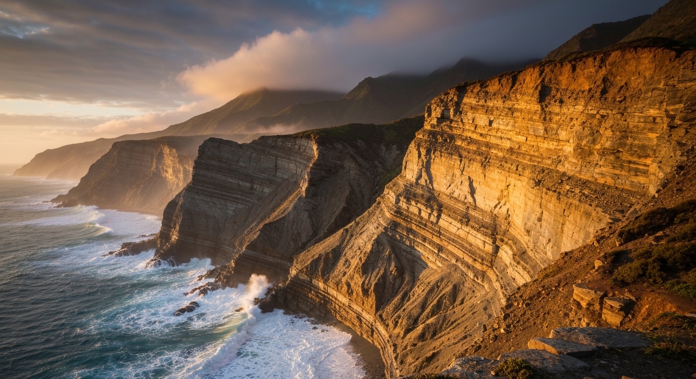
La Guaira Coastal Geology: A Shoreline Under Pressure
La Guaira coastal geology presents a paradox. The shoreline is simultaneously ancient and constantly changing. The bedrock exposed along the coast is some of the oldest and hardest rock in Venezuela — the same metamorphic assemblages that form the mountain range. But the coastal processes operating on and around that bedrock are dynamic, continuous, and heavily influenced by both natural forces and human intervention.
A Narrow Coastal Plain Built on Alluvium
The flat strip of land on which La Guaira's urban area sits is not underlain by bedrock. It's built on alluvial fans and deltaic deposits — material washed down from the mountains over thousands of years by rivers and debris flows. This distinction matters enormously for earthquake risk. When seismic waves travel through loose, water-saturated sediments, a process called liquefaction can occur. Soil that behaves like a solid under normal conditions suddenly behaves like a liquid when shaken, causing buildings to sink, tilt, or collapse entirely. The alluvial foundation of La Guaira's coastal plain is exactly the type of material most vulnerable to liquefaction during a major earthquake.
Marine Terraces and Sea Level History
Careful geological mapping along the La Guaira coastline has identified a series of marine terraces — flat benches cut into the rock at elevations above the current sea level. These terraces record periods when sea level was higher, or when the land was lower, relative to the present configuration. Their existence tells geologists that the coastline has experienced significant vertical movement over geological time, driven by the same tectonic forces that built the Cordillera. Some terraces show evidence of rapid uplift, consistent with thrust faulting in the subsurface. Others show subtle tilting that reflects the complex three-dimensional strain field operating at the plate boundary.
The Port and Its Geological Challenges
Building and maintaining a major port on La Guaira's coastline has always been a geological challenge. The narrow coastal plain leaves almost no room between the mountains and the sea, which is why so much of La Guaira's port infrastructure involves reclaimed land — areas where fill material has been placed in the shallow ocean to create usable flat ground. Reclaimed land is even more vulnerable to earthquake liquefaction than natural alluvial deposits, because the fill is typically less compacted and more heterogeneous. Engineers working on Caribbean geology La Guaira port projects must account for this layered vulnerability: soft fill sitting on alluvium, all of it overlying fractured bedrock, all of it within 50 kilometers of multiple active fault systems.
Quick Comparison
| Factor | La Guaira (Venezuela) | San Juan (Puerto Rico) |
|---|---|---|
| Tectonic setting | Caribbean-South American plate boundary (transform/compressional) | Caribbean-North American plate boundary (subduction-dominated) |
| Primary fault type | Strike-slip with compressional component (San Sebastián system) | Normal and thrust faults (Puerto Rico Trench region) |
| Dominant rock type | Metamorphic schists, phyllites, eclogites | Volcanic and carbonate rocks, limestone karst |
| Coastal plain material | Alluvial fan deposits, reclaimed fill — high liquefaction risk | Mixed alluvium and coral-derived sediments |
| Earthquake hazard level | Very high — multiple active fault systems within 50 km | High — major subduction zone to the north |
| Landslide risk | Extreme — steep slopes, fractured metamorphic rock | Moderate — lower relief, karst terrain |
| Port infrastructure challenge | Extremely narrow coastal plain, significant reclaimed land | More coastal space available, coral reef complications |
Timeline / Key Milestones
- 100–200 Million Years Ago: Protoliths of the Caracas Group metamorphic rocks are deposited as seafloor sediments on the ancient Caribbean ocean floor, beginning their long journey toward becoming the rock walls behind La Guaira.
- Approximately 80–60 Million Years Ago: Major subduction and accretion events along the northern South American margin drive high-pressure metamorphism, creating the blueschist and eclogite facies rocks of the Villa de Cura Belt — rocks that will eventually be exposed at the surface near La Guaira.
- Miocene Epoch (23–5 Million Years Ago): Continued plate convergence uplifts the Cordillera de la Costa, building the mountain range that now towers directly behind La Guaira and creating the steep, landslide-prone topography that defines the region.
- 1812: A major earthquake (estimated magnitude 7.7) devastates Caracas and the northern Venezuelan coast, killing thousands and demonstrating the lethal potential of the fault systems that underlie La Guaira. The event occurs on Holy Thursday — its timing becoming part of Venezuelan historical memory.
- December 1999: Extreme rainfall — some stations recording over 900 millimeters in two days — triggers catastrophic debris flows and landslides along the Vargas coast. Between 10,000 and 30,000 people are killed. The disaster exposes the full extent of geological vulnerability on La Guaira's alluvial coastal plain.
- 2009: A magnitude 5.9 earthquake strikes off the coast near La Guaira, causing damage and panic, and prompting renewed discussion about earthquake preparedness in Venezuela's most geologically exposed coastal zone.
- Recent Decades: A seismic event reportedly reaching approximately 7.5 magnitude affects the La Guaira region, resulting in more than 160 deaths and approximately 11,000 missing persons, and prompting the declaration of a disaster zone — the latest reminder that the plate boundary beneath the city remains active.
Key Numbers
Pros and Cons
Pros
- La Guaira's metamorphic bedrock is some of the hardest, most durable rock in Venezuela — where exposed at the surface, it provides excellent foundation material for major infrastructure.
- The tectonic activity that makes the region seismically dangerous has also built the dramatic topography that creates one of South America's most visually striking coastal environments.
- Geological complexity means significant mineral potential in the broader Cordillera de la Costa region, including historical deposits of copper, gold, and chromite in associated rock units.
- The narrow coastal setting, while geologically hazardous, has concentrated infrastructure development, making La Guaira's port one of the most efficiently positioned in terms of deep-water access in the southern Caribbean.
- Active geological research on the region's fault systems and rock formations contributes to broader scientific understanding of Caribbean-South American plate boundary dynamics.
Cons
- The city sits directly on multiple active fault systems, giving it one of the highest earthquake risk profiles of any major port in South America.
- Alluvial and reclaimed-land foundations throughout the urban and port areas create extreme liquefaction vulnerability during seismic events.
- Steep, fractured metamorphic slopes directly above the city produce catastrophic landslides and debris flows during heavy rainfall — often triggered or worsened by seismic activity.
- The narrow coastal plain leaves virtually no room for lateral expansion of infrastructure away from geological hazard zones.
- Geological conditions make tunneling, highway construction, and major civil engineering projects exceptionally complex and expensive — the road between La Guaira and Caracas is one of the most geologically challenging highway corridors in Venezuela.
- Limited flat stable ground means that population growth has historically pushed people onto steep, unstable slopes — concentrating the most vulnerable communities directly in landslide and earthquake hazard zones.
The Bigger Picture
Most conversations about La Guaira focus on economics — the port's throughput, Venezuela's oil exports, the political instability that has complicated trade for decades. The geology barely gets mentioned. That's a significant blind spot, because the geological story of La Guaira is not background context. It is the defining constraint on everything that happens there.
Consider the fundamental problem: you have a nation that depends heavily on its main port for imports of food, medicine, and manufactured goods. That port sits on some of the most geologically hazardous real estate in the entire Caribbean basin. The foundations are vulnerable to liquefaction. The slopes above the city are permanently primed for failure. The fault systems running through the region are capable of producing earthquakes above magnitude 7. And the infrastructure connecting the port to the capital city climbs a mountain range built from fractured metamorphic rock along a road corridor that geologists would never have chosen if they'd had a vote.
This isn't a problem that engineering alone can solve, though better engineering certainly helps. Seismic-resistant construction, slope stabilization, early warning systems, and rational land use planning could dramatically reduce the death toll when — not if — the next major event occurs. But the underlying geology doesn't change. The plate boundary keeps moving at its 20 millimeters per year. The fault systems accumulate stress. The steep slopes stay steep. Understanding that reality is the first step toward building a city that can actually coexist with its geological setting rather than repeatedly being surprised by it.
What's particularly striking about La Guaira rock formations is how legible they are to anyone who looks. The mountains behind the city are visibly layered, folded, and fractured. The narrow coastal plain is obviously alluvial — you can see the fans spreading from each river valley. The geological story isn't hidden. It's written in plain sight, in rock, for anyone who knows how to read it. The problem is that for most of the city's history, very few decision-makers have been fluent in that language.
The 1999 Vargas disaster killed tens of thousands of people in a single day. The geological conditions that produced that disaster were well-understood before it happened — Venezuelan geologists had mapped the unstable slopes, identified the debris flow corridors, and documented the landslide history. What was lacking was the political will and institutional capacity to translate that geological knowledge into effective land use restrictions and early warning systems. This gap between geological knowledge and governance is not unique to Venezuela, but it is particularly costly in a place where the geological hazards are this severe and this well-documented.
La Guaira's geology is also a reminder that the Caribbean basin, for all its association with tourism and blue water, is one of the most tectonically active regions on Earth. The 2010 Haiti earthquake killed over 200,000 people in a country sitting on a similar Caribbean plate boundary system. The geological forces operating across this region are not minor inconveniences. They are civilizational-scale risks that deserve civilizational-scale attention and investment in understanding them.
Frequently Asked Questions
What is the geological composition of La Guaira?
La Guaira's geology consists primarily of ancient metamorphic rocks — schists, phyllites, and eclogites — forming the Cordillera de la Costa mountain range directly behind the city. The coastal plain itself sits on younger alluvial fan deposits and, in the port area, on reclaimed fill material. This combination of hard bedrock under steep slopes and soft sediment on the flat coastal strip creates a geologically complex and hazardous environment.
How was La Guaira formed geologically?
La Guaira's current form reflects millions of years of tectonic activity at the Caribbean-South American plate boundary. Ancient seafloor sediments were buried, metamorphosed under intense heat and pressure, and then uplifted to form the Cordillera de la Costa. Erosion of those mountains deposited alluvial fans on the narrow coastal strip, creating the flat land on which the city was eventually built. The whole sequence spans roughly 100 to 200 million years of geological history.
What tectonic plates affect La Guaira?
La Guaira sits at the boundary between the Caribbean Plate and the South American Plate. The Caribbean Plate moves roughly eastward relative to South America at approximately 20 millimeters per year. This creates a transform-dominated margin with significant compressional components, generating both strike-slip and thrust earthquakes across the region. The complexity of this boundary — involving oblique convergence rather than simple lateral movement — is what makes northern Venezuela so seismically active.
What minerals are found in La Guaira?
The metamorphic rocks of the La Guaira region contain quartz veins, garnet-bearing assemblages, and minerals characteristic of high-pressure metamorphism such as glaucophane and jadeite in blueschist facies rocks. The broader Cordillera de la Costa geological belt contains historical deposits of copper, gold, and chromite. However, La Guaira itself is not a significant mining district — the economic geology interest is primarily academic and related to understanding the region's tectonic history.
What is the coastal geology of La Guaira?
La Guaira coastal geology features a narrow strip of alluvial and deltaic sediments sitting against steep metamorphic rock slopes, with the port area partially built on reclaimed land. Marine terraces above the current shoreline record past episodes of tectonic uplift and sea level change. The coastline is actively shaped by wave erosion of the exposed metamorphic bedrock in some areas, and by sediment deposition from mountain rivers in others. Liquefaction risk in the alluvial zones is a major engineering concern.
How does La Guaira's geology impact the port?
La Guaira's port faces significant geological challenges. The narrow coastal plain limits expansion options. Much of the port infrastructure sits on reclaimed land, which is highly vulnerable to liquefaction during earthquakes. Steep slopes directly above the port are prone to landslides that can block access roads and damage facilities. Deep-water access is good due to the steep offshore bathymetry — also a product of the tectonic setting — but overall geological hazard levels make the port one of the more vulnerable major facilities in the Caribbean.
Why does La Guaira experience so many earthquakes?
La Guaira sits directly on the boundary between the Caribbean and South American plates, one of the most seismically active margins in the Western Hemisphere. Multiple fault systems — including the San Sebastián fault — run through or near the city. The oblique nature of plate convergence in this area generates earthquakes of different types at various depths, making the seismic hazard both frequent and diverse. Historical records going back to 1812 document the region's long pattern of major seismic events.
What happened during the 1999 Vargas disaster and what does it reveal about La Guaira's geology?
In December 1999, extreme rainfall — approximately 900 millimeters in roughly two days — saturated the steep, fractured metamorphic slopes above La Guaira and triggered catastrophic debris flows and landslides. Between 10,000 and 30,000 people were killed. The disaster revealed how the combination of geological factors — steep fractured rock, thin unstable soils, alluvial fan deposits on the coastal plain, and a narrow strip of land with nowhere to escape — creates a uniquely dangerous environment when natural systems reach their limits.
Is La Guaira at risk of a major earthquake in the future?
Yes, unambiguously. The fault systems beneath La Guaira continue to accumulate tectonic stress. Historical patterns, geological mapping, and seismological monitoring all indicate that the region is capable of producing earthquakes in the magnitude 7 range or higher. The question is not whether a major event will occur but when, and how prepared the city's infrastructure and population will be when it does. Current geological evidence does not suggest any reduction in seismic hazard level.
How do the La Guaira rock formations compare to other Caribbean geological settings?
La Guaira's metamorphic rock assemblages are actually among the most scientifically significant in the Caribbean, containing high-pressure blueschist and eclogite rocks that record ancient subduction history. Many Caribbean islands are built on volcanic or carbonate rocks — geologically younger and very different in character. La Guaira's metamorphic basement is older, harder, and more complex, making it both more stable as a foundation in bedrock areas and more challenging for construction and tunneling in fractured zones.
Summary
La Guaira geology is the story of a city built in one of the worst geological locations imaginable — and somehow making it work, most of the time. Ancient metamorphic rocks form the mountain walls. Alluvial fans and reclaimed fill form the urban floor. Multiple active fault systems run through the region, capable of magnitude 7-plus earthquakes. Steep slopes store catastrophic potential energy every rainy season. The Caribbean and South American plates will keep grinding against each other at 20 millimeters per year, indifferent to port schedules or economic crises. The geology has always been the story here. The ground itself has just been waiting for someone to read it properly — and take the answer seriously enough to act on it.